Australian researchers have created the first ever interior 3D map of Italy’s iconic Leaning Tower of Pisa by using a breakthrough mobile laser mapping system.
Developed by Australia’s national science agency, the CSIRO, the Zebedee technology is a handheld 3D mapping system incorporating a laser scanner that sways on a spring to capture millions of detailed measurements of a site as fast as an operator can walk through it.
Specialised software then converts the system’s laser data into a detailed 3D map.
While the tower’s cramped stairs and complex architecture have prevented previous mapping technologies from capturing its interior, Zebedee has enabled the researchers to finally create the first comprehensive 3D map of the entire building.
“This technology is ideal for cultural heritage mapping, which is usually very time consuming and labour intensive,” says Dr Jonathan Roberts, research program leader at CSIRO’s Computational Informatics Division.
“It can often take a whole research team a number of days or weeks to map a site with the accuracy and detail of what we can produce in a few hours.”
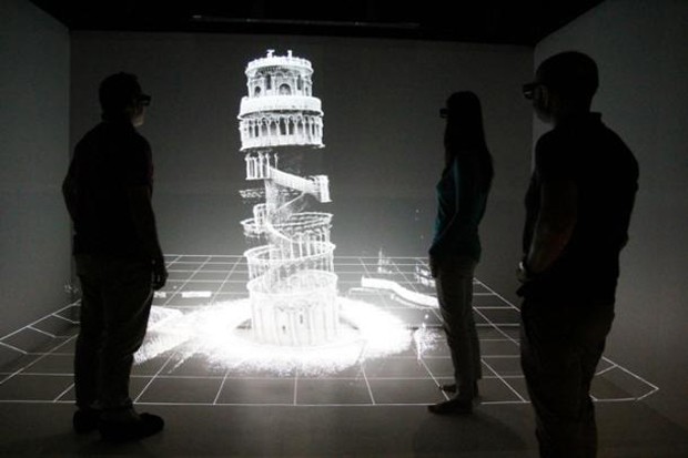
Within 20 minutes, Roberts’ team was able to use Zebedee to complete an entire scan of the building’s interior, allowing them to create a comprehensive and accurate 3D map of the tower’s structure and composition, including small details in the stairs and stonework.
‘Project Pisa’ involved a collaboration between CSIRO and local Italian scientists from Scuola Superiore Sant’Anna (SSSA), who believe that the research will significantly impact the preservation of the site’s cultural heritage.
“Our detailed record of the Leaning Tower of Pisa may one day be critical in being able to reconstruct the site if it was to suffer catastrophic damage due to natural disasters such as a fire or an earthquake,” says Franco Tecchia, assistant professor at the PERCRO – Perceptual Robotics lab.
“Having a detailed 3D model of the world’s most significant cultural heritage sites could also be used to allow people who cannot physically visit these sites to better understand and appreciate their history and architecture.”
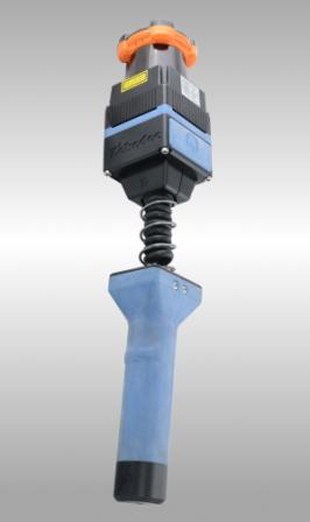
In 2012, CSIRO through its Digital Productivity and Services Flagship worked with 3D Laser Mapping, a global developer of laser scanning solutions, to commercialise the Zebedee research into the ZEB1 product.
Apart of its applications in cultural heritage, ZEB1 is currently also being used to increase efficiencies and improve productivity in a number of different industries. For instance, the technology is already assisting mining companies to better manage their operations, as well as help security forces to quickly scan crime scenes.
CSIRO’s Zebedee research was recently awarded a 2013 Eureka Prize for Innovative Use of Technology. The Australian national science agency’s breakthrough 3D mapping system was also recognised as the winner of the Research and Development category at the iAwards, Australia’s premier ICT awards program.
Images: CSIRO and geodatapoint.com
