Cumberland City Council and McGregor Coxall have jointly released the Duck River Parklands Strategic Masterplan (DRPSM), developed by the landscape architecture firm. The masterplan, zeroing in on the Western Sydney river, will transform its waterfront into a vibrant green corridor for residents and visitors alike.
The document, released last month, identifies a number of environmentally significant riparian zones for protection and water quality concerns, with key environmental strategies including waterway and bushland restoration, riverbank erosion mitigation, litter and plastics prevention, and native revegetation.
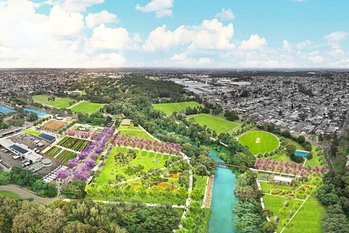
Duck River runs north-to-south through Granville, South Granville, Auburn, and Chester Hill, forming part of Sydney’s Green Grid network. It sits within a densely built urban area, with a clear lack of parks and open spaces, with 15 percent of land use public open space. For reference, Western Sydney and Greater Sydney’s percentages sit at 27 and 26 percent respectively.
“Council’s vision for the future of the Duck River at a local level is to ensure this key green corridor remains the “green heart” of Cumberland,” says Cumberland City Council Mayor, Lisa Lake.
“I am very excited to see the Duck River Parklands Strategic Masterplan come to fruition which has so much potential to create more spaces for our community to connect and grow. The river’s ecosystem and grasslands provides opportunities for access along its banks and environmental habitats, as well as open spaces for recreational activities.
“Council’s Duck River Parklands Strategic Masterplan outlines future projects, ideas and interventions for environmental and recreational development, community use and interaction through the suburbs of Clyde, Auburn, South Granville, and Chester Hill.
“Council is committed to the Strategic Masterplan for the Duck River Parklands and is very excited to see the revitalisation of this green corridor for our residents and the wider community.”
McGregor Coxall Associate Director Joel Dalberger says the masterplan will assist in creating a green spine through the LGA.
“Ecological degradation in the wake of industrial development, paired with an anticipated population growth of 30 percent by 2036, necessitates a vision for a community space that champions cultural vibrance and ecological conservation,” he says.
“The extension of nature reserves and enhancement of tree canopy throughout the Parklands will support the green infrastructure critical to the reduction of urban heat, improving air, water, environmental conditions, and improving liveability and outdoor activity, ensuring intergenerational benefits for all Western Sydney and beyond.”
Five new precincts have been earmarked by the practice, which will be linked via gateway entry points and a continuous active transport link. Currently unused green space will be reinvigorated, becoming local parklets and interfaces that integrate the parklands with nearby commercial and industrial developments.
The masterplan is supported by Council’s plan to provide short-, medium- and long term projects and initiatives to achieve this vision. Community play space and environmental projects are currently under detailed design and due for construction in the coming years.
For more information regarding the masterplan, click here.
